Jesusland, Internet Memes Don't Always Get Noticed.
This is the first time I’ve heard of this (meme circulating since 2004), which is remarkable to me because I started to blog in January of 2005 due to the reelection of George W. Bush (I thought I saw all the negitivity there was about that election). George W Bush, the most (or one of the most) inept presidents’ we have ever had, still could not be taken out of office by the Democrats, during a legal ELECTION? It was devastating to those who call themselves freethinking liberals but also it hurt the ones who identify with the ignorant on the red side of the mythical Jesusland map. Because of Dubya's reelection (a weak man under the control of his puppet master, Cheney) our country had been brought to its knees. Common Sense had to wait until Barack Obama came on the scene and through all the shenanigans the Republicans could pull to take away voters’ rights, through all odds, he was elected and we-the-people (even the uninformed) had a chance to witness the return of the sanity (or the illusion of) it once possessed. thinkingblue
PS: AND THEN CAME 2010 AND JESUSLAND INSANITY TOOK HOLD AGAIN!

Jesusland
Town to town
broadcast to each house, they drop your name
but no one knows your face
Billboards quoting things you'd never say
you hang your head and pray
for Jesusland
Jesusland
Miles and miles
and the sun goin' down
Pulses glow
from their homes
You're not alone
Lights come on
as you lay your weary head on their lawn
Parking lots
cracked and growing grass you see it all
from offices to farms
crosses flying high above the malls
A longer walk
through Jesusland
Jesusland
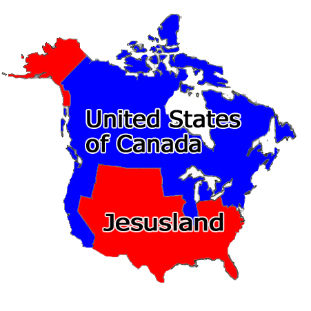
The Jesusland map is an Internet meme, created shortly after the 2004 United States Presidential election, which satirizes the red/blue states scheme by dividing the United States and Canada into "The United States of Canada" and "Jesusland". The map implies the existence of a fundamental political divide between contiguous northern and southern regions of North America, the former including both the socially liberal Canada and the West Coast, northeastern, and north-Midwestern states of the USA, and suggests that these states are closer in spirit to Canada than to the more conservative regions of their own country. The Freakonomics blog opined that the map reflected the "despair, division, and bitterness" of the election campaign and results.
The original image was created on November 3, 2004 by G. Webb, a poster on yakyak.org, an Internet message board for fans of the work of Jeff Minter. It quickly became an internet meme, which The New York Times described as an "instant Internet classic".
The original image was created on November 3, 2004 by G. Webb, a poster on yakyak.org, an Internet message board for fans of the work of Jeff Minter. It quickly became an internet meme, which The New York Times described as an "instant Internet classic".
posted by thinkingblue at 12:18 PM
![]()
![]()


<< Home